Every winter morning, millions of students wake up with one burning question on their minds: will school be closed today? Parents juggle work schedules, teachers wonder whether to prep a full lesson plan, and bus drivers eye the radar hoping for clarity. That anxious, half-awake ritual of refreshing weather apps and hunting for a school closing predictor has become a universal wintertime experience. Today, a new generation of tools promises something far more precise the ability to calculate snow day probability by city, giving families real answers before the alarm even goes off.
A snow day predictor is a digital tool that combines real-time meteorological data, historical school closure records, local geography, and increasingly, artificial intelligence to estimate the likelihood that a given school district will cancel classes due to winter weather. Unlike a basic weather forecast, which simply tells you how much snow might fall, a snow day calculator translates that raw data into something actionable: a percentage, a simple yes or no, or a detailed breakdown of contributing factors city by city and district by district.
This guide covers everything you need to know about how these tools work, how accurate they are, which ones to trust, and how to get the most out of them when a winter storm is bearing down on your community.
What Is a Snow Day Predictor?
A snow day predictor is essentially a weather-based school closure estimator. It ingests multiple streams of data current forecasts, storm tracks, temperature trends, predicted snowfall totals, wind speed projections, and road condition models and runs them through a calculation engine designed to mirror how school administrators actually make closure decisions.
The concept originated from simple community observations. People noticed that certain conditions, like a combination of overnight snowfall above a specific threshold, temperatures that prevent road treatment from working, and early morning timing, almost always led to school closures. Over time, enthusiasts and then professional developers began building systems to formalize those observations into calculators anyone could use from a phone or browser.
Modern tools go much further. They now pull real-time data from the National Weather Service, NOAA, commercial weather providers, and hyperlocal station networks. They factor in school district boundaries, historical closure records for that specific district, and even the time of year. A school district that has already used several of its allotted snow days may be more cautious about closing again later in the winter, and advanced predictors account for this pattern.
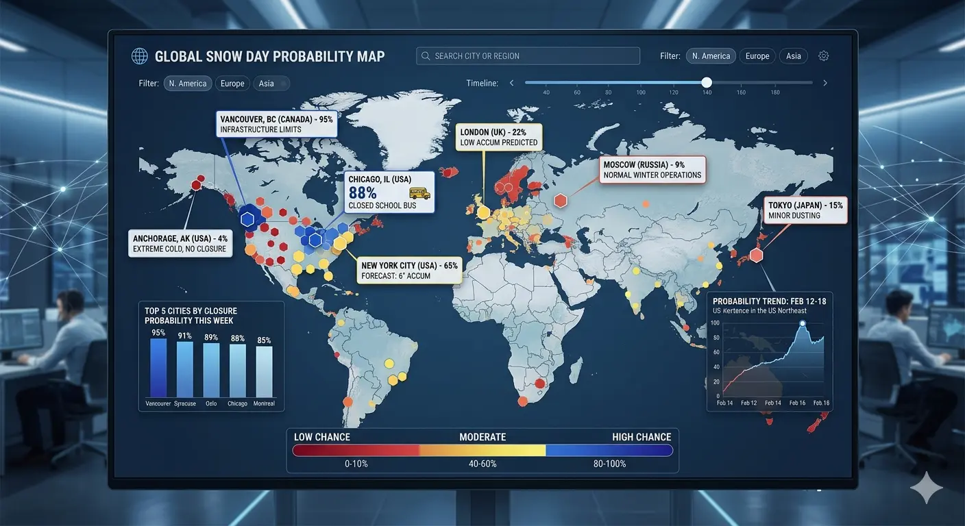
How Snow Day Probability by City Works
Understanding how snow day probability by city is calculated requires knowing what actually goes into a closure decision. These tools essentially try to replicate the thought process of a superintendent at 4 AM weighing a complex set of conditions.
First, the system retrieves the most current National Weather Service or commercial weather forecast for the user's city or zip code. It looks at projected snowfall totals across different time windows how much snow will fall between midnight and 6 AM, between 6 and 9 AM, and so on. Timing matters enormously because three inches of snow that falls by 2 AM gives road crews time to treat highways before school buses roll. The same three inches falling between 5 and 7 AM is a completely different situation.
Temperature is the next critical variable. Snow that falls at 31 degrees Fahrenheit, just barely below freezing, is wet and heavy and melts quickly once roads are treated. Snow at 10 degrees is dry and powdery but can be moved easily. The genuinely dangerous scenario for road conditions tends to sit in the mid-twenties to mid-teens range, where snow compacts and refreezes as a layer of ice underneath fresh accumulation.
Wind speed plays a substantial role in closure probability. Even modest snowfall totals become major disruptions when high winds create whiteout conditions and drifts that pile back onto roads minutes after plows clear them. Many school districts have explicit wind chill thresholds below which they cancel classes regardless of snowfall, especially for younger students who wait outdoors for buses.
The predictor then weighs these factors against the historical behavior of that city or district. If a certain school system has closed every single time snowfall exceeded four inches in the last five years, the model assigns a very high probability when that threshold is forecast. If a different district in a snowbelt region has gone multiple seasons without closing despite regular heavy snow, the model reflects that resilience accordingly.
The Science Behind the Snow Day Calculator
A well-built snow day calculator is more than a weather lookup tool. It is a probabilistic model that weights multiple variables based on their historically demonstrated influence on school closure decisions. The mathematics behind this can range from a weighted scoring system to a full machine learning regression model trained on years of closure data.
The foundational inputs most calculators use include total snowfall accumulation, rate of snowfall in inches per hour, low temperature at the expected morning commute time, wind speed and gust forecasts, precipitation type such as snow versus freezing rain versus sleet, timing of peak snowfall relative to morning bus routes, and road conditions forecasted by state and municipal transportation departments.
Some advanced tools also incorporate visibility forecasts, barometric pressure trends that indicate storm intensity changes, and even sunrise time, because a storm that hits after sunrise is far less disruptive to morning school operations than one that peaks in the predawn hours.
| Factor | Why It Matters | Impact Level |
|---|---|---|
| Snowfall Total | Primary accumulation threshold used by most districts | Very High |
| Timing of Snowfall | Overnight snow allows plowing before bus routes; morning snow does not | Very High |
| Temperature | Determines ice formation, treatment effectiveness, and wind chill | High |
| Wind Speed | Creates drifts, reduces visibility, increases dangerous wind chill | Medium-High |
| Precipitation Type | Freezing rain and sleet create worse road conditions than snow alone | High |
| District History | Some districts close easily; others rarely do regardless of conditions | Medium |
| Snow Days Used | Districts with few days remaining may be more conservative | Lower |
Snow Day Predictor Accuracy: What You Can Realistically Expect
No snow day predictor is perfectly accurate, and understanding why helps set realistic expectations. Weather forecasting itself carries uncertainty, and school closure decisions involve human judgment that no algorithm can fully replicate. That said, top-tier predictors consistently achieve accuracy rates between 80 and 90 percent when a clear weather event is approaching.
Accuracy degrades significantly for borderline events. When forecast snowfall sits right at a district's unofficial closure threshold say, three to four inches for a system that typically closes at four even a slight shift in the storm track can change the outcome completely. In these marginal scenarios, a snow day calculator is more useful as a probability indicator than a definitive answer.
Accuracy is also heavily tied to forecast lead time. Predictions made the evening before an event are significantly more reliable than those made three or four days out. Most users find that checking 24 to 36 hours before the school day provides the best balance of accuracy and advance notice. A forecast made 72 hours in advance might give you a 40 percent probability, which can jump to 85 percent by the evening before as the storm solidifies in the models.
Users in regions with infrequent snowfall should note that southern and mid-Atlantic school districts tend to close at lower accumulation thresholds than northern districts, meaning prediction models calibrated for those regions account for that sensitivity. A two-inch snowfall in Georgia carries a fundamentally different closure probability than the same amount in Minnesota, and reputable snow day calculators reflect this geographic nuance.

Snow Day Probability by City and Snow Day Predictor by Zip Code
One of the most significant improvements in modern snow day prediction is hyperlocal resolution. Early tools provided state-level or metropolitan-area-level estimates that were too broad to be genuinely useful. Today's best systems deliver snow day probability by city and in many cases by individual zip code, reflecting the reality that weather conditions can vary enormously across a single metro area.
The difference between zip codes within a single school district can occasionally be consequential, but the more important distinction is between different school systems within the same city or county. A city school district and a suburban district a few miles away may respond very differently to identical weather, based on their bus fleets, the terrain of their routes, the socioeconomic circumstances of their families, and their administrative risk tolerance.
A predictor that operates at the zip code level typically pulls hyperlocal weather station data, accounts for elevation differences between neighborhoods, and cross-references the specific school district serving that zip code rather than averaging across a broad region. This level of specificity is particularly valuable in hilly or coastal cities where weather can vary block by block.
To use a zip code-based snow day predictor effectively, simply enter your five-digit zip code rather than a city name. This ensures the tool queries the weather data and district history most relevant to your specific address rather than a city-wide average that might not reflect your neighborhood's conditions.
AI Snow Day Predictor Tools Are Changing the Game
Artificial intelligence is increasingly the backbone of the most sophisticated snow day calculators available today. Traditional rule-based systems applied fixed thresholds: if snowfall exceeds X inches and temperature falls below Y degrees, the probability is Z percent. These approaches worked reasonably well but could not adapt to nuanced patterns or learn from past errors.
Machine learning-based snow day predictors train on historical datasets that pair weather conditions with documented school closure decisions across thousands of districts over many years. The model learns not just the obvious patterns but the subtle ones as well: the fact that this particular district almost always closes when freezing rain is mixed in even at low accumulations, or that another system reliably stays open unless snowfall exceeds six inches regardless of other factors.
Natural language processing is beginning to enter the picture as well. Some newer tools scan school district social media accounts, automated phone systems, and email notification histories to further refine their models. If a district's communications show a pattern of early-morning closure announcements following specific weather keywords in forecast discussions, the AI incorporates that signal.
Deep learning approaches can also process radar imagery and satellite data directly, identifying storm structures that historically produce higher disruption even before official snow total forecasts are finalized. This gives AI-powered tools a meaningful head start in identifying high-impact events that more traditional approaches might underestimate.
Best Snow Day Predictor Websites for Students and Parents
A handful of websites and apps have established themselves as genuinely reliable resources for winter storm prediction and school closing probability. The best of these share several characteristics: they update frequently as new forecast data arrives, they provide transparency about their methodology, and they offer district-level resolution rather than generic city-wide guesses.
What to look for in a trustworthy snow day prediction platform includes regular data refreshes timed to major weather model update cycles, which typically run every six hours. The tool should clearly state when its data was last updated so you know whether you are looking at this afternoon's models or something from yesterday morning. Sources of weather data should be reputable, drawing from NWS, NOAA, or established commercial providers rather than unverified feeds.
User interface matters more than it might seem. A tool that presents its probability as a single clear number or a straightforward scale from very unlikely to very likely is often more useful than one that buries the answer in technical meteorological language that parents and students cannot easily interpret at 6 AM on a Tuesday.
Community features such as user-reported closures and local feedback can supplement algorithmic predictions, particularly for smaller districts or rural communities where historical closure data is sparse. When real people in a district are actively confirming or contradicting the tool's prediction, the overall accuracy of the platform improves for everyone using it in that area.
School Closing Predictor: How Do Districts Actually Decide?
Understanding how a school closing predictor works requires understanding how school districts themselves reach closure decisions. The process is more complex and more human than most people realize, and it sheds important light on why even very good predictors sometimes get it wrong.
Most decisions are made by a superintendent or their designee, often in consultation with transportation directors and facilities managers. The process typically begins between 3 AM and 5 AM on the day in question. Officials check the latest weather forecasts, contact their road crew supervisors to learn about actual conditions on critical bus routes, and sometimes drive key roads themselves to assess conditions firsthand.
The threshold question is not just how much snow has fallen or will fall, but whether school buses can safely navigate every route in the district. A district may have hundreds of route segments, some on well-maintained state highways and others on rural roads that receive lower priority from municipal plows. The condition of the worst routes, not the average, drives the decision.
Wind chill is particularly consequential for districts that include elementary students who wait outdoors at bus stops. Many districts have explicit policies: if wind chill is forecast to reach a certain level before or during school hours, they cancel regardless of road conditions. This means a cold, windy day with relatively little snow can still result in a closure that a pure accumulation-based predictor would miss.
Liability is another unspoken factor. School administrators are acutely aware that a decision to stay open during deteriorating conditions, followed by a bus accident or a student injury at an icy bus stop, is far more professionally and legally damaging than an overly cautious closure that turns out to be unnecessary. This asymmetry of consequences tends to push decisions toward closure in ambiguous situations.
Forecast vs. Actual Closure: Why They Sometimes Diverge
One of the most common frustrations among snow day calculator users is the scenario where a tool shows high probability but school stays open, or vice versa. Understanding why these divergences happen makes the tools more useful rather than less trustworthy.
Weather forecasts have irreducible uncertainty, especially at the local level. A storm that models consistently showed producing five inches overnight might instead deposit two inches with a last-minute shift in its track. Road crews who had a smooth, efficient night of treatment may have highway conditions in excellent shape by 5 AM. The superintendent drives the roads, finds them passable, and keeps school open despite what the forecast suggested the previous evening.
The reverse also happens. A storm that looked modest on paper can interact with local geography to produce localized heavier bands. Low-lying districts might experience rapid ice formation when temperatures drop faster than models predicted. A predictor showing 40 percent probability might correspond to a situation that actually triggers a closure because of these unpredictable local factors.
The most honest snow day predictors acknowledge this uncertainty explicitly. Rather than presenting a 72 percent probability as a near-certainty, they frame it as meaningful but not definitive — a reason to prepare, not a guarantee to celebrate.
Snow Day Predictor for Students: Making the Most of the Waiting Game
For students, checking a snow day predictor has become something of a winter ritual, and there are definitely better and worse ways to approach it. Understanding what the numbers actually mean transforms the experience from anxiety-inducing speculation into genuinely useful planning.
When a predictor shows probability below 30 percent, the honest advice is to complete your homework and prepare for a regular school day. Below-30 scenarios do occasionally result in closures, but not often enough to justify the risk of being unprepared. When probability reaches the 60 to 75 percent range, it is reasonable to mentally prepare for a snow day while still setting an alarm and having your bag packed. Above 80 percent, a closure is considerably more likely than not, though still not certain.
One effective habit is to check the predictor at two specific times: once at dinner time the evening before, and once immediately before going to bed. The gap between these two checks often reveals whether the forecast is solidifying in one direction or becoming less certain as new data arrives. A probability that rises from 55 to 72 percent between 6 PM and 10 PM is telling you the storm is tracking better than initially modeled and confidence is growing.
Latest Trends in Snow Day Prediction Technology
The field of snow day prediction is evolving rapidly, driven by advances in weather technology, data infrastructure, and artificial intelligence. Several trends are reshaping what these tools can do and how reliable they have become.
Real-Time Data Integration
Modern predictors now ingest data from an expanding network of sources simultaneously. Connected weather stations mounted on school buses, road sensors embedded in pavement, satellite imagery updated every few minutes, and IoT devices measuring road surface temperatures in real time all feed into increasingly sophisticated prediction engines. This real-time data integration dramatically improves accuracy for short-range predictions made within 12 to 24 hours of a weather event.
Machine Learning and Ensemble Modeling
Weather agencies and private forecasters increasingly rely on ensemble models — running dozens of slightly different versions of the same weather simulation simultaneously to capture the range of possible outcomes. Snow day predictors are beginning to incorporate ensemble output directly, presenting probability ranges that reflect the actual spread of model solutions rather than a single deterministic forecast. A prediction based on 50 ensemble runs is fundamentally more trustworthy than one based on a single model run.
Mobile App Experiences
Dedicated mobile apps have made snow day probability checking a seamless experience. Push notifications set for 5 AM delivery, location-aware automatic district detection, historical track records for your specific district, and side-by-side comparisons with other weather apps all make the mobile experience genuinely useful rather than just convenient. Some apps allow parents to set probability thresholds above which they receive an automatic overnight alert, removing the need to remember to check at all.
Social Media Signal Processing
Leading platforms are beginning to mine social media and school district communication channels for early signals. When a district superintendent follows an unusual pattern of weather-related posts late at night, or when the district's automated messaging system is accessed at 3 AM, a smart predictor can factor that behavioral signal into its probability estimate. These soft signals sometimes provide earlier warning than meteorological data alone.
Personalized Prediction Profiles
Some tools now allow users to build personalized profiles that track the specific quirks of their district over time. If your district has a pattern of staying open despite heavy snow but closing whenever freezing rain is involved, a personalized profile will reflect that tendency and weight its predictions accordingly. This kind of customization dramatically improves relevance compared to generic city-wide estimates.
How to Predict a Snow Day Manually When Apps Are Not Available
Technology aside, many experienced school community members have developed reliable intuitions for when a snow day is coming. These manual approaches complement digital tools and can be useful when connectivity is limited or when you want a quick gut-check independent of an app.
The first thing to check is the National Weather Service forecast for your area, specifically the Hazardous Weather Outlook and Area Forecast Discussion documents. These are written by local meteorologists who understand regional terrain and they often convey a level of specificity and nuance that automated tools translate imperfectly. When a local NWS office issues a Winter Storm Warning rather than a Winter Storm Watch, the probability of school closures rises substantially because warnings indicate high confidence in significant impacts.
Next, examine the timing of the precipitation. Pull up a radar loop and see when the snow line is expected to reach your area. A storm arriving after midnight that tapers off by 4 AM is often manageable. One arriving at midnight and continuing through 8 AM is a much stronger candidate for closure.
Temperature trajectory matters too. Check the hourly forecast and note whether temperatures are expected to stay below 32 degrees throughout the morning or briefly dip and then rise. A brief dip that ends with temperatures rising above freezing by 7 AM suggests roads will clear reasonably quickly once treated. A sustained freeze through mid-morning suggests ice persisting on secondary roads well into the school day.
Finally, consult local media. Television meteorologists in most markets have direct relationships with school district officials and sometimes receive early signals about closure inclinations. A meteorologist who says on the 11 PM news that they would expect widespread closures tomorrow morning is drawing on knowledge that an automated tool cannot access.
Tips for Using a Snow Day Predictor More Effectively
- Use multiple sources simultaneously. No single predictor has a monopoly on accuracy. Cross-referencing two or three tools and noting where their probabilities cluster gives you a better read on the true likelihood than trusting any single platform exclusively.
- Check timing, not just totals. Always look at when the heaviest snow is forecast, not just how much. Total accumulation is less important to closure probability than whether that accumulation happens before or during morning commute hours.
- Know your district's history. Spend ten minutes researching how your specific district has behaved in past storms. This background knowledge helps you calibrate whether a predictor's probability feels high or low relative to how your administration actually responds.
- Check between 8 PM and 10 PM the night before. This is when the most recent and reliable model data is available. Earlier checks are useful for awareness but carry more uncertainty than evening-before predictions.
- Do not confuse probability with certainty. An 85 percent snow day probability means approximately one in six such situations does not result in a closure. Plan accordingly rather than treating the number as a guarantee.
- Sign up for district notifications. Official closure announcements from your school district are always the definitive source. Use predictors for advance planning but rely on official communications for the final answer.
- Account for regional climate culture. A predictor calibrated for a northern snowbelt district may overestimate closure probability when applied to a southern district where even modest snowfall triggers widespread disruption. Choose tools that distinguish between these regional norms.

Snow Day Chances Calculator: Understanding the Percentage
When a snow day chances calculator presents a probability number, users sometimes struggle to interpret what it actually means in practical terms. A 65 percent probability is not a confident prediction and not a coin flip either. Understanding the probabilistic nature of these outputs makes them much more actionable.
Think of the percentage as representing what would happen if you replayed the same atmospheric setup a hundred times across many different communities. In 65 of those replays, conditions led to a school closure. In 35, they did not. Both outcomes are plausible. The weather conditions do not change, but the human decision-making, the variability in exactly when the snow falls, and small differences in local conditions produce different outcomes across the distribution.
For planning purposes, a rough mental framework works well. Below 25 percent: prepare for a normal school day, no special action needed. 25 to 50 percent: be aware, watch for updates, have a contingency plan forming in the back of your mind. 50 to 75 percent: actively prepare for a snow day, arrange backup childcare if needed, complete important tasks tonight. Above 75 percent: high confidence in a closure, plan accordingly while staying alert for the official announcement.
Read More : Best Snow Day Predictor Online
Conclusion: Embracing Winter Weather with Confidence
Snow day prediction has evolved from a guessing game into a genuinely sophisticated discipline that combines atmospheric science, historical data analysis, and artificial intelligence. For families navigating busy winter schedules, the ability to access reliable snow day probability by city before the first flake falls represents a real quality-of-life improvement — less anxiety, better planning, and fewer last-minute scrambles for childcare or backup lessons.
The best approach is to use these tools as one part of a broader winter weather awareness strategy. Check your preferred snow day calculator the evening before a storm, cross-reference it with your local National Weather Service forecast, and know your school district's specific closure tendencies. When those elements align and all the signals point the same direction, you can make confident plans well before the official announcement arrives.
As AI and machine learning continue to advance, and as real-time data feeds grow more granular and reliable, snow day probability by city predictions will only become more accurate and more useful. For now, they are already far better than waking up at 5 AM and pressing your face against the window hoping for a miracle. Use them wisely, plan ahead, and stay warm.